

WELLBEING WALKS

Explore local routes from your train or bus stop
Discover car-free walking trails in Gloucestershire, designed to support physical and mental wellbeing.
Our maps combine creative projects, inclusive mapping, and local knowledge to create walking, cycling and active travel routes that begin where people usually travel, like train stations and bus stops. These routes lead to quiet green spaces, riverside paths, and hidden local spots.
Whether you’re looking for a short lunchtime stroll, a new way to explore your town, or a confidence-building route for your next journey, these maps offer something accessible, free and local.
Tewkesbury Wellbeing Walks
New for 2025 – shaped by the people who live there
Our newest map was co-created with local residents and community groups through a series
of creative workshops in partnership with Art Shape, From knitters and walkers to support
groups and local artists, each person helped shape the routes, artwork and focus of the map.
The result is four walking routes that:
-
Start from local bus stops linked to Ashchurch-for-Tewkesbury station
-
Include a mix of short and longer walks — from the Secret Garden trail (80m) to a 2km
riverside and railway heritage route -
Highlight quiet, reflective spaces, local landmarks and the voices of the people who use them
Download the map here: Tewkesbury Wellbeing Walks Map
Creative Mindfulness
Enhance your walk with creative mindfulness activities
This resource has been developed by Art Shape and local artists, as part of the Tewkesbury Wellbeing Walks
project. These creative exercises add a mindful dimension to your wellbeing walks. These activities are perfect
for anyone looking to connect with nature, supporting mental wellbeing through gentle artistic expression.
Whether you try shadow drawing with plants and landmarks, create nature-inspired line drawing, or make
mindful doodles of your discoveries, these simple exercises help you slow down and engage your senses.
Go at your own pace, it's about the process, not perfection.
Download here: Creative Walks Activities (PDF)
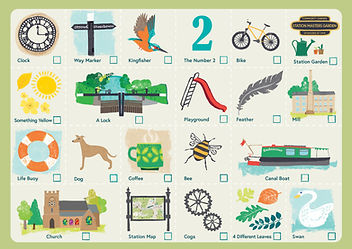
Canal Rail Trail BINGO!
Add excitement to your canal walk with our interactive bingo challenge
Created by the GCRP team, this fun activity sheet turns your walk into a rewarding
discovery experience. This bingo challenge is perfect for families and friends
wanting to make their walk more engaging, helping everyone spot wildlife
and features along the way.
Whether you find a colourful kingfisher, notice historic mill, or watch narrowboats
navigate the locks, this bingo sheet encourages you to observe the fascinating
details that can be overlooked or missed. Take your time and enjoy the discovery
on your way to BINGO!
Download here: Canal Rail Trail Bingo (PDF)
Gloucester Wellbeing Walks
Hidden green spaces – just minutes from the city centre
Created by the GCRP team, the Gloucester Wellbeing Walks map showcases four accessible routes all starting from Gloucester train station.
These routes are perfect for:
-
Short walks during lunch breaks or before/after commuting
-
Quiet spots for mindfulness, nature connection or light exercise
-
Helping newcomers discover safe, walkable routes through the city
Whether you want to walk along the canal, loop around Alney Island or explore Llanthony Priory Gardens, this map gives you simple, step-by-step routes linked directly to public transport.
Download the map: Gloucester Wellbeing Walks Map (PDF)
Why we do this
We believe that walking, wellbeing and transport shouldn’t exist in silos. These maps:
-
Help people connect with local nature and heritage
-
Reduce barriers to walking and public transport
-
Are shaped by the people who use them
-
Encourage people to discover local outdoor spaces
-
Support inclusive, accessible, low-carbon travel options
Our Wellbeing Walks projects put lived experience and local knowledge at the heart of travel planning.
Want to help shape the next route?
We’re always looking for new towns, partners and community groups to help us co-create the next map. If you have an idea for your local area, or want to collaborate on a wellbeing project near a train station or bus stop, we’d love to hear from you.


